

|
THE FOLLOWING MAP IS NOT TO BE USED FOR NAVIGATIONAL PURPOSES.
|
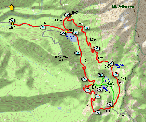
Length: 17 miles
Elevation Change: 2900' elevation gain
Season: Summer thru Fall
Difficulty: Difficult
Permit: Special Pass Required - Detroit Ranger Station
GPS:
Latitude: 44.66
Longitude: -121.89127
Features:
This is one of the most popular hiking
destinations in the Mt Jefferson Wilderness
area. After one visit, you'll see why. This place is
just plain fantastic!
Keep in mind you must obtain a special use
permit to hike/camp in the Pamelia Lake / Hunts
Cove area of the Mt Jefferson Wilderness.
Pamelia Lake or Hunts Cove Limited Entry Permits
in the Detroit Ranger District of the Willamette National Forest must be
obtained on line at www.recreation.gov
or by calling the Reservation Line at 1-877-444-6777. If a person wants to get the
permit on the day of the hike, they can call it in and stop by the Detroit Ranger Station
and they will print their permit for them.
Cost: $6.00
Summer hours: 7 days a week 8-4:30 Memorial Day
thru Columbus Day
Regular hours: Monday-Friday 8-4:30
The trail to Pamelia Lake begins fairly gently
as it follows Pamelia Creek most of the way
to the lake. From time to time you will have
excellent opportunities to enjoy the creek
and it's beautiful cascades.
At about 2.3 miles you will come to the shore
of Pamelia Lake. Your first sight of this
gorgeous lake can be overwhelming, depending
on the weather and season.
You can do this loop hike through Hunts Cove
either clock-wise or counter-clock-wise. I
choose to do the hike clock-wise. Thus my
description will follow that order.
Bear left upon reaching the trail junction at
Pamelia Lake. This trail will lead to another
trail on the northeast side of the lake. It is
this trail that you will want to follow up to
the Pacific Crest Trail, which you will use to
take you along the east side of Pamelia Lake and
Hunts Cove.
It is about a mile climb to the PCT. Bear right
on the Pacific Crest Trail and continue to climb
in a southerly direction along the eastern flank
of Pamelia Lake. There will be increasing view
opportunities as the trail gains elevation and
begins to leave the dense forested areas.
At about three miles you will come to a really
neat shallow lake called Mud Hole Lake. The
trail skirts the northwest side of the lake, and
at the western end of the lake you get great view
of Mt. Jefferson looming above you.
Continue on the PCT for about another half mile
and the trail breaks out on the ridge directly
above Hunts Lake and offers a splendid view of
Hunts Cove. Just continue on the PCT and in about
another two miles you will come to a junction to
a trail that leads back toward Pamelia Lake via
Hunts Cove.
You have a couple significant options at this point.
There is an older trail that leads from this area
directly down to Hanks Lake. The trail is not in
good condition but is much shorter that taking the
three plue mile option as seen on the map. Use your
own wisdom and discretion. I have nothing to urge.
Whichever route you choose, be sure to find your way
into Hunts Cove. This is a spectacular area of two
lakes and wildflowers and wonderful vistas. After
your visit, just return to the Pamelia Lake trail and
follow it downhill to Pamelia Lake.
You will need to cross the rather challenging Hunts
Creek. The trail follows the eastern shoreline of
Pamelia Lake and eventually connects with the very
trail that you were on when you began the loop. Just
follow the trail that brought you to Pamelia Lake back
to your vehicle. Enjoy one of the Jefferson Wilderness
most beautiful hikes.
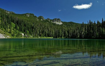
Hunt Lake in Hunts Cove
|
How to get there:
From Detroit Ranger Station travel East on Hwy 22 approximately 14 miles past Detroit to Pamelia Creek road.
Turn left onto Pamelia Creek road, travel about 5 miles to end of road. Trailhead parking is on the left.
|
|
|
A Virtual Hike of the Mount Jefferson Wilderness Area


|
|


