
|
THE FOLLOWING MAP IS NOT TO BE USED FOR NAVIGATIONAL PURPOSES.
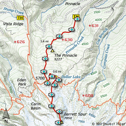
Map of the Pinnacle Ridge Trail Hike
|
Length: 12.4 mi RT
Elevation Change: 4153' gain
Season: Summer thru Fall
Difficulty: Very Difficult
Permit: NW Forest Pass Not Required
GPS: N45 26.8386 W121 41.1018
Latitude: 45.44731
Longitude: -121.68503
Features:
NEW!
Click for PDF Topo Map of this Hike
I hiked this trail many years ago, yet never considered it an alternate route to Barrett Spur,
until now. Sure, you can use the Pinnacle Ridge trail to reach any number of wonderful places
on the north side of Mt. Hood, such as Dollar Lake, Wyeast Basin, and Elk Cove. But, I've decided
to present this hike as an alternative route to Barrett Spur, especially for those living on the
eastern side of the Cascades.
The trail isn't as popular as many other trails leading to the alpine regions of Mt. Hood, but
it is well worth the time and effort to enjoy its own unique characteristics. Just getting to
the trailhead is a worthwhile adventure, even it you didn't hike. The drive up to Laurance Lake
is spectacular, and then the drive up the canyon and ridge to the Pinnacle Ridge trailhead presents
some of the most outstanding views of Mt. Hood.
Like all the other approaches to the mountain, in season you will be presented with a wonderful
display of avalanche lilies, then lupine and paintbrush, plus many other beautiful wildflowers.
If there is a disadvantage in using this trail to reach the timberline, it is the beginning
elevation. At only 3700 feet, it is 900 feet lower than the Vista Ridge trailhead, so you are
faced with climbing this additional elevation. Nevertheless, for variety and possible ease of
location it is still a viable alternative.
The first two and a half miles of this trail takes you through fairly dense forests. Right at the
base of the Pinnacles, you do see the rock formation, but for the most part you have no views until
you reach the soggy meadow areas about a half mile before the Timberline Trail. In season this is
a favorite playground of the common mosquito and it will be only delighted to relieve you of part
of your blood supply. So, go prepared for combat!
Even in late July you are likely to run into snow before reaching the Timberline Trail, but the
junction is well marked, and just bear left and head east on your hunt for the elusive Dollar Lake.
I say that because it seems to be one of the best unkept secrets of the mountain, and I say secret,
because no one seems to want to mark the path you need to follow to find the lake. I'm still not
quite sure how come I always do find it, because the place where you leave the Timberline trail
simply is not marked, indicated, flagged, signed or otherwise apparent to the average hiker.
So, how do I explain to you how to find it? As you hike east along the Timberline Trail, you will
break out into a fairly open area where you have outstanding views of Mt. Adams and Mt. Rainier to
the north. The trail leaves the confines of the larger trees and takes you into a bit of a draw,
as it sweeps gently to the left. It is here that the unmarked user trail leaves the Timberline Trail
on your right and heads up that very draw. Almost immediately you will see the users trail or trails.
Depending on the snow conditions the trail varies just a bit. If you don't see or find this elusive
trail, you will come to a very open area, and then the trail makes a steep right turn and begins to
head downhill. This will tell you that you've missed the Dollar Lake trail, and need to backtrack.
When you do find the users trail to Dollar Lake, follow it up the draw and through the trees to the lake.
There are obvious places all around this area to camp if you want to stay overnight. To climb Barrett
Spur, which will be right in front of Mt. Hood as you view it from Dollar Lake, just follow the very
obvious user trail leading from the lake up the mountain. Having said that, please heed a word of warning.
I take no implied or stated responsibility for your attempt to climb Barrett Spur.
Also, be aware that a forest fire burned much of this area in recent years.
The ascent of this rocky ridge can be dangerous to limb if not to life. This is not a child's game and should
be treated with the absolutely greatest caution and respect. BE CAREFUL if you insist on going up there.

Mt. Hood viewed from the road to the Pinnacle Ridge Trailhead
|
How to get there:
NEW!
Click for PDF Directions Map of this Hike
Follow Highway 35 from either Government Camp or Hood River to the town of Parkdale.
Turn south on Clear Creek Road and follow this road for 2.8 miles to Laurance Lake Road.
Turn right, and stay on this road for 4.2 miles to Laurance Lake Campground. Turn left
here on gravel Forest Road 2840, passing the Elk Cove Trailhead spur on the right after one mile.
FR 2840 climbs through overgrown clearcuts for another 1.8 miles to the Pinnacle Ridge trailhead.
About a half mile before the trailhead, you will be treated to exceptional views of Mt. Hood.
|
|
|
A Virtual Hike of the Mount Hood National Forest


|
|


